
Thursday 9th, 2009.
We departed the Atherton Tablelands in Northern Queensland at 8:30 and headed further North to Cairns to check in for the Charter flight to Rabaul, Papua New Guinea. After a short flight of 2 hours and 15 minutes we arrived at the airport to be greeted by the Orion team. Our passports, immigration and customs forms were quickly collected, along with our bags and we were provided with a welcome cold drink and our room keys and loaded onto small buses for the transfer to the ship. May I just say that if the rest of our trip is anything like the experience of driving from the Airport to Rabaul we can’t wait. Every person stopped and waved at us, the warm smiles and greetings made us feel like we were the attraction. May I just say that the roads in Papua New Guinea are an adventure of their own, there do not seem to be distinct lanes or road rules. Let’s just say that gross tonnage and small pigs rule the local roads!
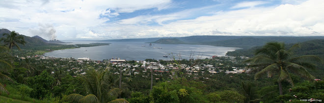
Rabaul is located on New Britain Island which is the largest island in the Bismarck Archipelago (named for Otto von Bismarck) of Papua New Guinea. It is separated from the island of New Guinea by the Dampier Strait, and from the New Ireland by the St George’s Channel. The main towns of New Britain are Rabaul/Kokopo and Kimbe. New Ireland and New Britain islands get their names from the fact that their outlines on a map roughly correspond to those of the British Isles in the Atlantic Ocean.
New Britain extends from 148 to 152 E. Longitude and from 4 to 7 S latitude. It is crescent shaped, approximately 600 km along its southeastern coastline and from 30 to 110 km wide, not including a small central peninsula. The island is the 38th largest in the world.
Steep cliffs form some sections of the coastline; in others the mountains are further inland, and the coastal area is flat and bordered by coral reefs. New Britain was largely formed by volcanic processes and there are several active volcanoes on the island, including Uluwan (the highest volcano in Papua New Guinea), Langila, the Garbuna Group, the Sulu Range, and the volcanoes Tavurvur and Vulcan of the Rabaul caldera. A major eruption of Tavurvur in 1994 destroyed the East New Britain provincial capital of Rabaul. Most of the town still lies under meters of ash, and the capital has been moved to nearby Kokopo.
Tomorrow, we will take small local boats across the harbor to the base of Mt. Tavurvur for the Volcano Adventure. The Volcano has been rather active of late so we are looking forward getting up close……… will provide an update on the experience tomorrow night.
A Little History:
William Dampier became the first known European to visit New Britain on February 27 1700: he dubbed the island with the Latin name Nova Britannia in November 1884, Germany proclaimed its protectorate over the New Britain Archipelago; the German colonial administration gave New Britain and New Ireland the names of Neupommern (New Pomerania) and Neumecklenburg ( New Mecklenburg), and the whole group was renamed the Bismarck Archipelago.
On 11 September, `1914, New Britain became the site of one of the earliest battles of World War 1 when the Australian Naval and Military Expeditionary Force landed on the island quickly overwhelming the German forces and German New Guinea became the Australian Territory of New Guinea.
We departed the Atherton Tablelands in Northern Queensland at 8:30 and headed further North to Cairns to check in for the Charter flight to Rabaul, Papua New Guinea. After a short flight of 2 hours and 15 minutes we arrived at the airport to be greeted by the Orion team. Our passports, immigration and customs forms were quickly collected, along with our bags and we were provided with a welcome cold drink and our room keys and loaded onto small buses for the transfer to the ship. May I just say that if the rest of our trip is anything like the experience of driving from the Airport to Rabaul we can’t wait. Every person stopped and waved at us, the warm smiles and greetings made us feel like we were the attraction. May I just say that the roads in Papua New Guinea are an adventure of their own, there do not seem to be distinct lanes or road rules. Let’s just say that gross tonnage and small pigs rule the local roads!
Rabaul is located on New Britain Island which is the largest island in the Bismarck Archipelago (named for Otto von Bismarck) of Papua New Guinea. It is separated from the island of New Guinea by the Dampier Strait, and from the New Ireland by the St George’s Channel. The main towns of New Britain are Rabaul/Kokopo and Kimbe. New Ireland and New Britain islands get their names from the fact that their outlines on a map roughly correspond to those of the British Isles in the Atlantic Ocean.
New Britain extends from 148 to 152 E. Longitude and from 4 to 7 S latitude. It is crescent shaped, approximately 600 km along its southeastern coastline and from 30 to 110 km wide, not including a small central peninsula. The island is the 38th largest in the world.
Steep cliffs form some sections of the coastline; in others the mountains are further inland, and the coastal area is flat and bordered by coral reefs. New Britain was largely formed by volcanic processes and there are several active volcanoes on the island, including Uluwan (the highest volcano in Papua New Guinea), Langila, the Garbuna Group, the Sulu Range, and the volcanoes Tavurvur and Vulcan of the Rabaul caldera. A major eruption of Tavurvur in 1994 destroyed the East New Britain provincial capital of Rabaul. Most of the town still lies under meters of ash, and the capital has been moved to nearby Kokopo.
Tomorrow, we will take small local boats across the harbor to the base of Mt. Tavurvur for the Volcano Adventure. The Volcano has been rather active of late so we are looking forward getting up close……… will provide an update on the experience tomorrow night.
A Little History:
William Dampier became the first known European to visit New Britain on February 27 1700: he dubbed the island with the Latin name Nova Britannia in November 1884, Germany proclaimed its protectorate over the New Britain Archipelago; the German colonial administration gave New Britain and New Ireland the names of Neupommern (New Pomerania) and Neumecklenburg ( New Mecklenburg), and the whole group was renamed the Bismarck Archipelago.
On 11 September, `1914, New Britain became the site of one of the earliest battles of World War 1 when the Australian Naval and Military Expeditionary Force landed on the island quickly overwhelming the German forces and German New Guinea became the Australian Territory of New Guinea.


No comments:
Post a Comment