Thursday, April 16, 2009

Madang and Bilbil Village


MADANG – April 13th
Madang Province is some 300 kilometers long and 160kilometers wide encompassing four large and many small offshore islands. The province totals 27,970 square kilometers and has a population of over 240,000 people. To the south lie the towering Bismarck Ranges containing PNG’s highest mountain Mt Wilhelm (4509m). The warm Bismarck Sea laps the northern coast, and the region is drained northward by the larger Ramu, Sogeram, Gogol and Malas Rivers. The mountains are timber rich and with large stands of trees and rain forest, whilst the coastal plain is open and palm studded.

The Madang coast received its first real western exploration at the hands of the Russian explorer Nicolai Miklouha-Maclay in 1871. He introduced pineapples, mangoes, beans, pumpkins and other new foods. In 1884 the German New Guinea Kompangie started development of the region, building tobacco, cotton and coffee plantations at Bogia and around t Astrolabe Bay.
The city of Madang was occupied by the Japanese in the Second World War, on 1 May 1942. During the war Madang was destroyed in heavy fighting with much loss of life on both sides. The township was recaptured by allied soldiers on 24th April 1944. Post war developments have been few and mainly restricted to the coast and Madang town.

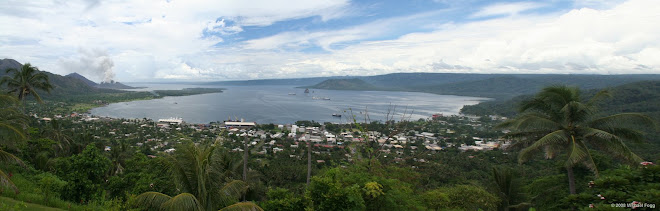
As we awoke today we slid into the bay with the Madang resort on our left and the stunning ranges on our right. The PNG Sport Fishing competition had just finished and there were still a number of large private fishing boats at anchor along the bay. We pulled up alongside the dock in Madang and were greeted by local dancers which I must admit is a wonderful way to start the day.

Madang is the stepping off point for the Goroka Highlands Adventure, a 30 minute flight up into the highlands to visit the amazing Mudmen of Goroka. This group departed Orion at 7:45am and shortly after the skies opened and the rain bucketed down, which caused a little reorganization of the Bilbil Village trip that I was booked on. Not a problem, we all donned rain coats and followed the Expedition Team on a tour of Madang and the Madang Resort.
Madang is famous for its Bat population and as you walk around the town you see thousands of them roosting in the trees. There are so many that flights into and out of Madang are timed around the Bats and their flight times. Basically if your flight isn’t out by dusk you are out of luck…….
The visit to the Madang Resort was great fun and this is a wonderful place to look for Ramu and Sepik masks, Bilums (bags) and other artifacts, these are located in a traditional building just inside the entrance to the Resort. Yes, I purchased two more masks, one rather large, and I am now wondering how on earth I am going to get it home. It is a stunning Sepik River mask and I can’t wait to share it with everyone. After our walk we boarded the shuttle bus for a quick tour of the city with a visit to the Coast Watchers monument, named after the few brave Australian military that stayed behind after the evacuation of Madang to watch and report on the Japanese occupation.

Apart from the guided walk there was also a Madang Scuba Dive tour available, which I understand was simply amazing. Marissa and Roland returned with stores of swimming with a pod of dolphins, diving on wrecks and stunning marine life. My friend Barbara took the opportunity to visit the Spa on board Orion for a relaxing massage and facial while I set off for Bilbil Village in the afternoon for the optional Bilbil Village Tour. BILBIL VILLAGE Overview: Prior to 1904, the Bilbil people lived on an island offshore from Madang, trading clay pots along the coast from Kar Kar Island to western Morobe. The island was too small to produce enough food for the inhabitants, and the trade therefore was an essential element of their life. They moved to the mainland to their existing village site to improve their subsistence levels.
Over the centuries the Bilbils have been great seaman, and they sailed their large two-masted canoes for hundreds of kilometers along the coast. They would call into many villages and trade their pots for food, wooden bowls, pigs and other trading goods.

The Bilbil Village Tour requires a 35 minute bus ride out of town through the lush green countryside on roads that were much more comfortable than Rabaul, but still and adventure of their own. The village is located on a beautiful black sand beach surrounded by palms and the traditional sago palm homes stand high off the ground to allow for the cool ocean breezes.
We were greeted by the local head man and after a quick walk around the village were seated for a presentation on pot making; this is what Bilbil is famous for. Local clay is mixed with the black sand and hand shaped into food and water containers. The process was very fast with the firing taking only minutes. These pots were traded for other items up and down the coast and are available for purchase. John and Colleen purchased a wonderful piece for Barbara’s Birthday gift. Did I mention how many wonderful friends we have made on board during our trip! After the pottery presentation we were treated to a traditional Sing Sing by the village and once again you wonder if it can get any better. I think I have over 300 photos of this particular group performing along with video so stand by for photo overload.

THE ASARO MUDMEN (Mudmen of Goroka) The Asaro Mudmen come from the village f Asaro just outside the town of Goroka in the Eastern Highlands Province of Papua New Guinea.
The legend that surrounds the reason the mud men appear the way they are, is that they were defeated by an opposing tribe and forced to flee into the Asaro River. They waited until dusk before attempting to escape. Arising from the muddy banks, the enemy saw them covered in mud and thought they were spirits. Most tribes in PNG are very scared of spirits so the enemy fled in fear and the Asaro Mudmen were victorious.

DEPARTING MADANG Like many tropical areas the heavy rain from the morning gave way to stunning blue skies in the afternoon for our Bilbil Village tour and return to Orion for departure at dusk.

Wednesday, April 15, 2009

Watam Village


Watam Village is the easternmost village in East Sepik Province and is situated at the northwestern end of Broken Water Bay. The Watam people originally came from further east in the lower sections f the Ramu River, where there are still spoken languages closely related to the Watam language. The Watam people migrated from there many generations ago along with the people of Kopar village at the mouth of the Sepik River. They purchased the land they now reside on, with an exchange of Women and Ritual Goods.

The social organization of the village is patrilineal, with the clan membership coming from one’s father. There are 7 clans today and each occupies a land section in the village. Each clan has its own Men’s house, around which ritual life revolves. Rituals involve platforms on which food and other offerings are placed, tallied and then distributed among villagers at important festivities and rituals. Unmarried men still sleep in the men’s houses.

The traditional religion was animistic, involving spirit and ancestor placating, but today all villages are nominally Catholic, although much of traditional ritual and beliefs survive.

The Sepik

The Sepik region is an immense grassland reserve, surrounded by one of the world’s greatest rivers which run 1,126 kilometers from the origins in the mountains to the sea. The people along the river depend heavily on it for transportation water and food.. Their national links with the Sepik River are symbolized in many of the ancient and spiritual rituals, such as the manhood initiation. This requires painful carving of flesh on the backs of young men with razor blades. Patterns are that of a crocodile lying on the banks of the river.

The history of the Sepik region reflects the influence over the years of the missionaries, traders, labor recruiters and administrators. Parts of the Highlands remain untouched just as they were when first discovered in 1933. In fact, some more villages have yet to see a white man.
The Sepik River has long been world famous for the quantity and quality of its wood carvings and for the imposing architecture of its Haus Tambarans – Spirit Houses. Traditionally, art in the Sepik was created in the service of magic, myth and ritual. Spirit houses were lined with shields decorated with the faces of ancestors, mythical being and nature spirits, whose likenesses appear also on masks, suspension hooks for food and on the pillars which supported the great soaring roof of the house. Ritual cannibalism was practiced as a means of protection against the spirit of an enemy killed in battle and for capturing his physical and spiritual powers. Often, the head was not eaten but pained and hung in the doorway of the spirit house as a symbol of prowess and to bar entry to women and the uninitiated.

The Sepik River has no actual river delta and stains the sea brown for up to 50 kilometers. It is said islanders off the coast can draw fresh water straight from the sea. The Sepik is navigable for almost its entire length and winds down through the land resembling a huge, brown coiling serpent.

WATAM VILLAGE - Sunday
Every evening we attend a pre briefing in the Leda Lounge that provides us with an overview of our activities for the next day, along with a detailed briefing on the history, culture and area. Saturday evening was all about Watam Village and what we should expect upon arrival. Including the “Stay behind the Dragon” briefing, I will explain later!

The next morning we all boarded the Zodiacs to travel across to Watam, it was important that we all arrive as one group for the official welcome by the village. As we traveled across we were greeted by two boats full of Watam Villagers singing and drumming and dressed in traditional Ramu dress, they then escorted us around the corner and Watam came into view. A ceremonial arch had been constructed from Sago Palm leaves and we all entered to be welcomed by the village. This began with the singing of the National PNG anthem and the PNG Pledge by the Watam school children; we then gathered behind Justin (Orion Expeditions) and awaited arrival of the Dragon.

The Dragon is actually a long sea serpent type costume that we were required to follow into the village. By doing so we were allowed to view village life that otherwise would have been taboo. In the eyes of the village we were all “men”! This procession was stunning with all 96 guests following the Dragon and being joined by Watam villagers. Children held our hands, adults walked beside us and friends were made immediately.

What a warm, welcoming and utterly open people. My friend Barbara was befriended by a lovely girl who invited us into her home, a traditional sago palm house on stilts.
We spent the morning at Watam wandering through the village, shopping in the market that had been set up by vendors from Watam and surrounding areas. Many of which had arrived by traditional wooden canoes from further up the Sepik river. The array of masks, bags, jewelry and crafts was spectacular.

The village itself is set in a small cove and each of the homes and men’s houses are built of traditional materials, primarily Sago, which is used for walls, ceilings and also as food. The surroundings are a stunning green that is hard to put into words and includes lush banana and sago palms and stunning orchids. PNG is renowned for its orchids.
I must admit that none of us wanted to leave our new friends and the beauty of Watam; however, the Sepik River was our next adventure.

After lunch back on board we headed out once again in the Zodiacs towards the mouth of the Sepik River. The river stains the sea brown for up to 50km, similar to a milk chocolate color. It was also a little choppy and we rode the waves which added to the excitement.

Once inside the mouth of the river we searched for local bird life, including Bromeny Kites, White Sea Eagles, Kingfishers and Bee Eaters. We also had the opportunity to get closer to local farming plots full of banana and sago. The bird life was amazing and we were able to get so close the Bromeny Kite, hence the 50 photographs from every angle…..

We then followed local canoes across the Sepik, which may I say is very fast running, towards Kopar. Local villagers will canoe up the river and then cross above their intended destination, using the Sepik’s current to carry them to their village. Kopar is sizeable village on the banks of the Sepik River. Children ran out to welcome us and played around the Zodiac while the rest of the village waved and smiled.

What I found most amazing is that none of the villagers ask for handouts. Not one guest was pushed for money and there is no haggling for items. You will be given “First Price” and then a “Second Price” usually in the same sentence and it is your call which price you pay. I selected a nice middle ground as “First Price” allows them to make some additional cash while “Second Price” is the cost of making the item.

Friday, April 10, 2009

Rabaul - Papua New Guinea


RABAUL – PAPUA NEW GUINEA
What an amazing day! We spent the night on board Orion in Simpson Harbor, Rabaul.
Rabaul is set at the eastern end of the island of New Britain and is famous for its spectacular setting. Nestled beside Simpson Harbor, the township is surrounded by six volcanoes, one of which, Mt Tavurvur, is currently active. During more than 100 years of settlement Rabaul has been rocked by massive volcanic eruptions and war. On 11th October 2006 at 10:00am local time Tavurvur erupted with ash reaching up to 25,000ft in elevation.

It is hard to explain how the town looks today. However, a visit to the New Guinea Club is a great way to become acquainted with the history and legacy of a town that was once known as the “Pearl” of the pacific. Today piles of black ash cover most of the old town and ash continues to fall daily over every inch of the town.

We started the day with the optional Volcano Adventure tour. We boarded buses (best available, which means exactly that, the best available) and headed with our local guide towards Mt Tavurvur and its column of ash. The closer we got to the volcano the more desolate the surroundings. This was once a thriving town of over 10,00 expatriates from all over the world that came to work on the coconut and cocoa plantations. Today very few of the original buildings remain except for concrete foundations.

The road is also covered in meters of ash, so much so that it completely disappeared the further we went until there were only sticks strategically placed in the ash with small blue pieces of plastic attached and a local guide who walked in front of the mini bus to ensure we didn’t get stuck. We arrived at a beach opposite the volcano and boarded local banana boats that ferried us across the foot of Mt Tavurvur, which may I say is quite daunting as it continually shoots huge clouds of ash and rock into the sky above you. A key safety hint, when you hear a bang look up and watch for falling lava…..then duck out of the way!

The water at the base of the volcano is rather warm and is full of a bright rust colored alga. Everything else is black ash or yellow sulphur ….another hint don’t hang out in the gullies, sulphur and carbon dioxide pool in these lower areas and can be deadly….basically keep moving. We walked along the base of the volcano taking some amazing shots of the ash plumes and moon like terrain before setting out to search for a local bird called the Megopod (Big Foot), a rather small bird with very large feet. This same bird digs very deep nesting holes around the base of the volcano and lays eggs that are 20% of their body size every 15 days. These eggs are a delicacy to the locals as they are predominantly yolk and there were several people digging them out during our visit. Each egg is worth about 2kina back in Rabaul so it is a rather good little business, if you can forget that you are hanging out at the base of an active volcano.

We also had the chance to see some World War II gun emplacements, very interesting!
We spent approximately 2 hours exploring the volcano and then boarded our banana boats for the return journey. When we reached the beach we were greeted by about 20 locals and children selling shell jewelry and woven bags. The children are amazing and love to have their photographs taken. Just make sure you are ready to share your digital images as they love to see themselves and their friends. I had the chance to meet a wonderful girl by the name of Brenda, who I chatted with for several minutes. As we were leaving she ran up to the bus and presented me with the most wonderful necklace as a parting gift. They are just so warm, friendly and gracious it is hard to put it into words.

I think the highlight of the day was the Easter procession that surrounded our mini bus on the way back to the ship. We were driving across a wide area of volcanic ash, everything is black, and then directly in front of us were over 200 people, dressed in bright colors carrying a huge white cross covered in yellow streamers and singing. It was stunning to say the least!
After lunch back on board we headed out on the shuttle bus to tour Rabaul with visits to the markets, Diabetic Center (run by an amazing German gentleman who provides assistance to diabetics the local community at no charge) the New Guinea Club which is adjacent to Yamamoto’s bunker and then the Rabaul Hotel.

The day culminated with our departure from Rabaul and one final opportunity to photograph Mt. Tavurvur from the comfort of Orion’s sun deck.

Tomorrow will be a sea day as we make our way across to Watam village on the Sepik River.

Thursday, April 9, 2009

PAPUA NEW GUINEA BOUND!


Thursday 9th, 2009.

We departed the Atherton Tablelands in Northern Queensland at 8:30 and headed further North to Cairns to check in for the Charter flight to Rabaul, Papua New Guinea. After a short flight of 2 hours and 15 minutes we arrived at the airport to be greeted by the Orion team. Our passports, immigration and customs forms were quickly collected, along with our bags and we were provided with a welcome cold drink and our room keys and loaded onto small buses for the transfer to the ship. May I just say that if the rest of our trip is anything like the experience of driving from the Airport to Rabaul we can’t wait. Every person stopped and waved at us, the warm smiles and greetings made us feel like we were the attraction. May I just say that the roads in Papua New Guinea are an adventure of their own, there do not seem to be distinct lanes or road rules. Let’s just say that gross tonnage and small pigs rule the local roads!

Rabaul is located on New Britain Island which is the largest island in the Bismarck Archipelago (named for Otto von Bismarck) of Papua New Guinea. It is separated from the island of New Guinea by the Dampier Strait, and from the New Ireland by the St George’s Channel. The main towns of New Britain are Rabaul/Kokopo and Kimbe. New Ireland and New Britain islands get their names from the fact that their outlines on a map roughly correspond to those of the British Isles in the Atlantic Ocean.

New Britain extends from 148 to 152 E. Longitude and from 4 to 7 S latitude. It is crescent shaped, approximately 600 km along its southeastern coastline and from 30 to 110 km wide, not including a small central peninsula. The island is the 38th largest in the world.

Steep cliffs form some sections of the coastline; in others the mountains are further inland, and the coastal area is flat and bordered by coral reefs. New Britain was largely formed by volcanic processes and there are several active volcanoes on the island, including Uluwan (the highest volcano in Papua New Guinea), Langila, the Garbuna Group, the Sulu Range, and the volcanoes Tavurvur and Vulcan of the Rabaul caldera. A major eruption of Tavurvur in 1994 destroyed the East New Britain provincial capital of Rabaul. Most of the town still lies under meters of ash, and the capital has been moved to nearby Kokopo.

Tomorrow, we will take small local boats across the harbor to the base of Mt. Tavurvur for the Volcano Adventure. The Volcano has been rather active of late so we are looking forward getting up close……… will provide an update on the experience tomorrow night.

A Little History:
William Dampier became the first known European to visit New Britain on February 27 1700: he dubbed the island with the Latin name Nova Britannia in November 1884, Germany proclaimed its protectorate over the New Britain Archipelago; the German colonial administration gave New Britain and New Ireland the names of Neupommern (New Pomerania) and Neumecklenburg ( New Mecklenburg), and the whole group was renamed the Bismarck Archipelago.

On 11 September, `1914, New Britain became the site of one of the earliest battles of World War 1 when the Australian Naval and Military Expeditionary Force landed on the island quickly overwhelming the German forces and German New Guinea became the Australian Territory of New Guinea.

Wednesday, April 8, 2009

Risotto, Rainforest & Rainfall


Imagine 9.08" of rain in one day! Now imagine sitting on a hardwood balcony overlooking a stunningly beautiful emerald green valley, surrounded by green tree frogs and sipping on a glass of chilled champagne and eating the best prawn risotto in my life.......you may think I am staying at some swanky resort in Cairns.


NO! Actually we are the guests of Pedro and Marg O'Connor of Epic Private Journeys. There home is nestled in the foothills of the Atherton Tableland in a little town called East Palmerston and I am in love! I awoke to the sounds of Australian birds today, rainbow lorikeets, butcher birds, whip birds, Olive Oriole and the sound of tropical rain through glass shutters.


We arrived last night from Sydney, after my flight from LAX on Qantas, which I must say was very enjoyable. I actually slept for 8 hours and arrived very refreshed into Sydney where I met up with Dee Mills, a long time friend who now works with Toga in Sydney. Dee kindly picked up my extra bag for storage, had a coffee with me, helped me get my new $69.00 Aussie Phone organized (you can purchase a phone as soon as you come through into the arrival hall) and dropped me at the Qantas domestic terminal to join my Cairns Flight, rather simple really.


From Sydney we arrived into Cairns via Qantas and picked up our little rental vehicle (imagine Mr. Been's car in white) and headed off on our adventure to pick up our Papua New Guinea Kina from the local Travelex office and then to head south on the Bruce Highway to Pedro and Marg's home. By now it was dusk and the sugar cane fields and banana plantations formed a long green tunnel out of town. We also hit torrential rains that slowed our progress down to a crawl at times but that is to be expected in Northern Queensland.
Today, Thursday morning April 9th, we will head back after a cuppa (cup of tea) and tropical fruit salad to Cairns to join Orion's charter flight to Rabaul.
Can you say EXCITED!

Thursday, April 2, 2009

Papua New Guinea - a little history!

I have been doing a little more reading on Papua New Guinea, its history in particular and I wanted to share a handy link that has provided me with some wonderful information.

http://www.historyofnations.net/oceania/papuanewguinea.html

Another site worth a visit is the Papua New Guinea Tourism website.

http://www.pngtourism.org.pg/

As always keeping the best for last! You can also read over the logs of previous Orion visits to Papua New Guinea. These are highly informative and provide an in depth overview of the destinations visited.

http://www.orionexpeditions.com/expeditions/png/voyage_logs

Enjoy! I hope to have my first blog post from Australia on April 7th.